Tuesday, August 30, 2011

Mopping up Salt at the Lake

Today's travel is to remain very light, we have to get the bike to Bailey's for shipping back to Massachusetts. This was a clean up day for things we didn't get the first day in Salt Lake City.

Right down the street from our hotel was this place. I thought it was pretty neat.


Off to Timpanogos Cave National Monument on UT 92. We were here last year, so this was a pure stamp grab, but I really enjoy the road leading up to this place. If you have a chance ride UT 92 also knows as Alpine Loop Road. You won't be disappointed.


We headed for Bingham Canyon Mine. This is world's largest open pit excavation and can be seen from outer space it is so large. If my daughter moves out here, I will be sure to go back to this place in the car.


We got to the gate and they would not let us go to the top because we were on a motorcycle. They feared stuff would fall on us and they might get sued. This was a pretty big disappointment. We headed off to two HD dealerships to buy tall shot glasses to add to my collection. Our last stop of the day was here. We killed 2 birds with 1 stone. A water town and a HD shot glass.


We headed to Bailey's, dropped off the bike and headed for a relaxing day at the hotel.

No animals were hurt, killed or maimed in the making of this trip. Phew !! Now to deal with Irene on the way home.


Wasted in Great Basin


We had a great stay at the Hotel Nevada. At first this place will appear to be run down dive, the rooms small and the water pressure/temp variable, but I have to say our stay was great. They warn you about the water, taking a negative and turning it into a positive. Great marketing !! The rest is nostalgia to the max, well to at least 1929 when the place was built.


Back out on Route 50 heading for Great Basin National Park right on the border of Nevada and Utah. The road didn't change much from yesterday.


Some of the warning signs became more specific.


Temps were getting up there again


We visited this place right on the border, grabbed a stamp, sneaked in a brief nap, watched the video and got back on US 50 heading to Utah.


Once we hit Utah, there were some subtle changes. The road went from white to black for one.


The hills became more mountain like and rugged.


And the clouds became a bit more ominous


What didn't change was the wind. It was breezy at times. But things did get greener.


And there was more signs of life.


But there were relapses into the straight and narrow.


We found ourselves back in civilization and finished up the day with a water town, then headed for the hotel for the night.


Friday, August 26, 2011

Over Hill, Over Dale, We hit the Dusty Trail

Before we left Reno I knew we had to ride to downtown and gets this picture.


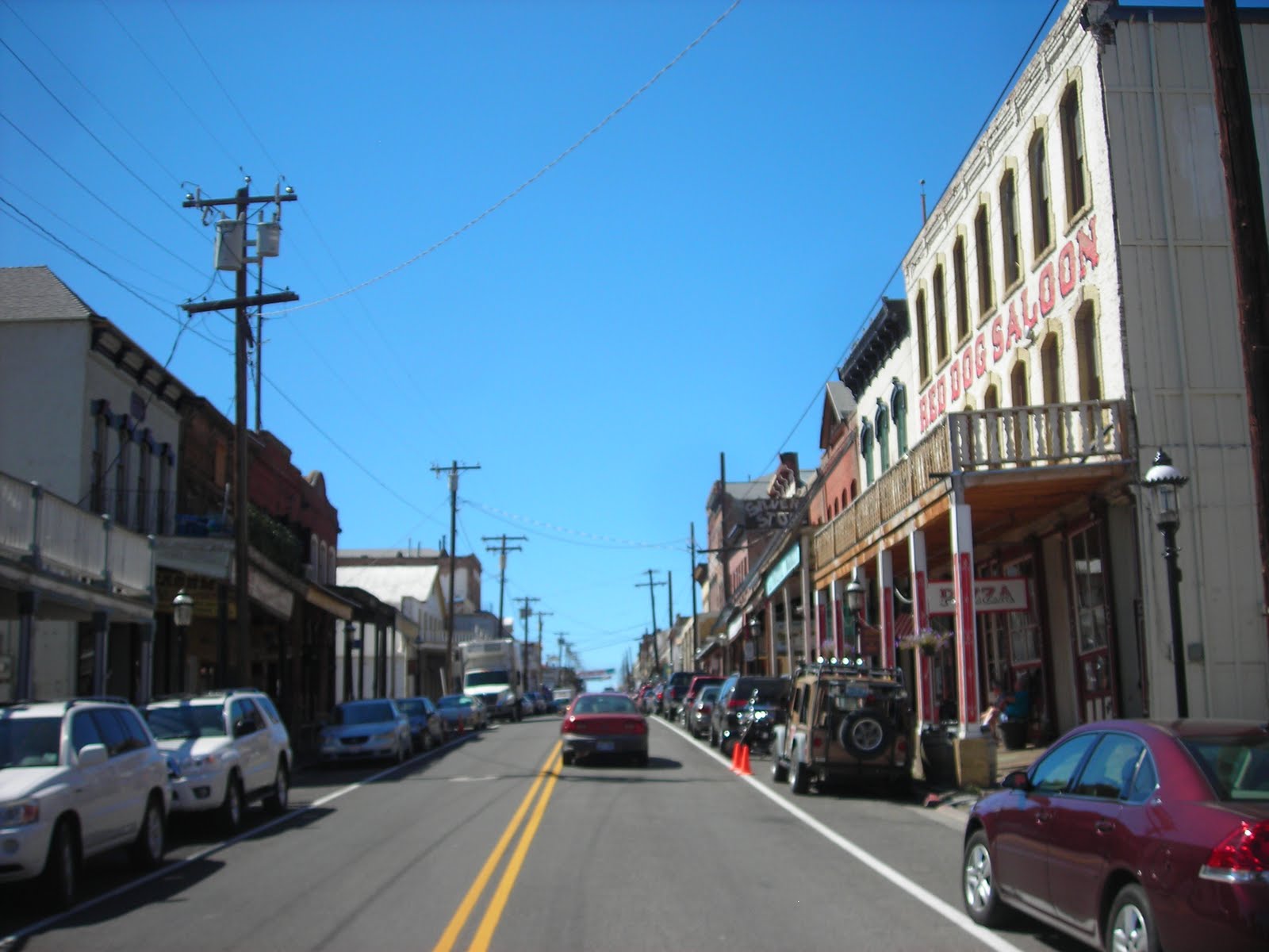
Heading out of Reno for Ely, NV we hit Virginia City as our first stop. This was mainly for the historic picture capturing than anything else. Initial part of the ride had us climbing some mountains, which will become the norm for the day. RT 341 is the road into Virginia City. As we climbed the mountains I was humming the theme song to Bonanza.


As you peak the top of hills you see Virginia City.


And then you are there.


First impression was this was a pretty touristy type of town. We grabbed some of, what I felt were, the more significant buildings and we got out of Dodge.


Heading out of town was more difficult for the GPS's than for us. One had us going in a different direction than the other. Looking at the roads I took the path of least resistance to US 50. Next stop was another historic landmark, Fort Churchill just outside Silver Springs. This was good grab for a water town as well.

Not alot out here other than ruins of the buildings for Fort Churchill, which was built to protect the early settlers and the Pony Express route. At some of these stops you have to use your imagination of what went on.


This was abit more out of the way than I anticipated, but on MapSource it was just so easy to incorporate into the route. Simple click, drag to the Waypoint and the route is amended.

At this point it is time to make time for Ely, NV on route 50, the loneliest road in America. You wouldn't want to break down on this road. There is not a whole lot of traffic on this road and only a handful of towns along the way. Keep an eye on your gas as well. You ride from mountain range to mountain range. Ride across the valley and climb over the mountain, drop down to the valley and ride to the next one.

The Valleys


The sign that indicates that this is a lonely road


The Hills


We hit some pretty high winds crossing Nevada. At one point there was a bit of rain, just enough to mix with the oil on the road, add a bunch of wind, forcing you to list the bike (in this case to the left) to add to the excitement. Some of the wind felt like it was going to blow the wheels right out from under you.

We pulled into Ely right around 6pm. I was so ready for a beer. We stayed at the Hotel Nevada which is a whole journey unto itself, and a good journey to boot. For 39.95 you get a room, a pretty good restaurant, fairly cheap drinks and gambling if you want. When we pulled up there must have been 25 HD's out in front and one FJR on the end. It looked so out of place.


The inside


I heard about these books, but I did not pick mine up until we hit Ely. Just as well, since all it could do was slow us down. I asked MeAsWe if she wanted to ride back to Reno to get our stamps and I got that look "Are you kiddin me?"


Thursday, August 25, 2011

Not Less at Lassen

We are getting down to the end of our trip. There are 2 or 3 more parks to visit while we are out West. I am sitting in our hotel in Redding, CA feeling kinda of knarly.

Heading a little more west to Whiskeytown National Recreational Area on Historic 99. Route 99 was the main highway that went from the border with Mexico to Blaine WA. It was like Route 66 that went north and south.


Whiskeytown was for a pure stamp stop in CA. Not that we needed it, but eventually it is my goal to have hit every park and this one is out of the way. Of note the Trinity Dam is one of the highest earth dams in the world.


We did pick up the Shasta Lake post office as a water town, and then headed for Lassen Volcanic National Park. Based on my brief reading in the prep stage this was a potential grab and run for the stamp. As all plans they are subject to change. Lassen Peak is the largest plug hole domed volcano in the world. There is one road thru Lassen and it is a beauty. Highest elevation the road reaches is 8600'. You feel like you are driving right to the top of the volcanoes. Snow abounds as well.


The Snow


Lassen Peak


We also got off the bike and took a walk looking for bears. Not sure what we would have done if we actually came across any. The walk did us some good, I think.


The flowers


From Lassen we headed for Reno. The roads leading out of Lassen were twisty, forested and interesting. Eventually they turned desert plains like. We followed this guy into Reno. A Hayabusa with twin Givi for side cases.


Locked up Nevada for Smoke Chasing 2011


Called it a night here